Rwenzori Mountains National Park
Over 1850 years ago, an Alexandrine photographer known as Ptolemy wrote of a snow capped mountain range deep in the heart of Africa, claiming it was the source of the world’s longest river, the mighty Nile. He named it Montes Lunae meaning ‘mountains of the moon’.
After a number of centuries, other explorers, researchers and mountaineers discovered that he actually meant the Rwenzori Mountain ranges in South Western Uganda shared with Congo.
The Rwenzori was placed on the modern map on the 24th of May 1888 by explorer Henry Stanley, labelling it ‘Ruwenzori’, a local name that means ‘rain maker’.
The Rwenzori is one of the most beautiful and highest mountains in Africa, with glaciers and highest peak called mt Margherita, Standing at an elevation of 5,109m. Its glaciers and snow peaks melt waters certainly representing the highest springs of the Nile as Ptolemy suggested.
It measures up to 110km long and 50km wide. It consist of six distinct mountains, Stanley (5109m), Speke (4890m), Baker (4843m), Emin (4797m), Gessi (4715m) and Savioa (4627m) and is managed by the Rwenzori mountains National Park. Each of these mountains bears their own crown of peaks.
The most popular is the 5109m Margherita, the highest point on Mountain Stanley and the roof of the Rwenzori.
The Park
Map of Rwenzori Mountain National Park
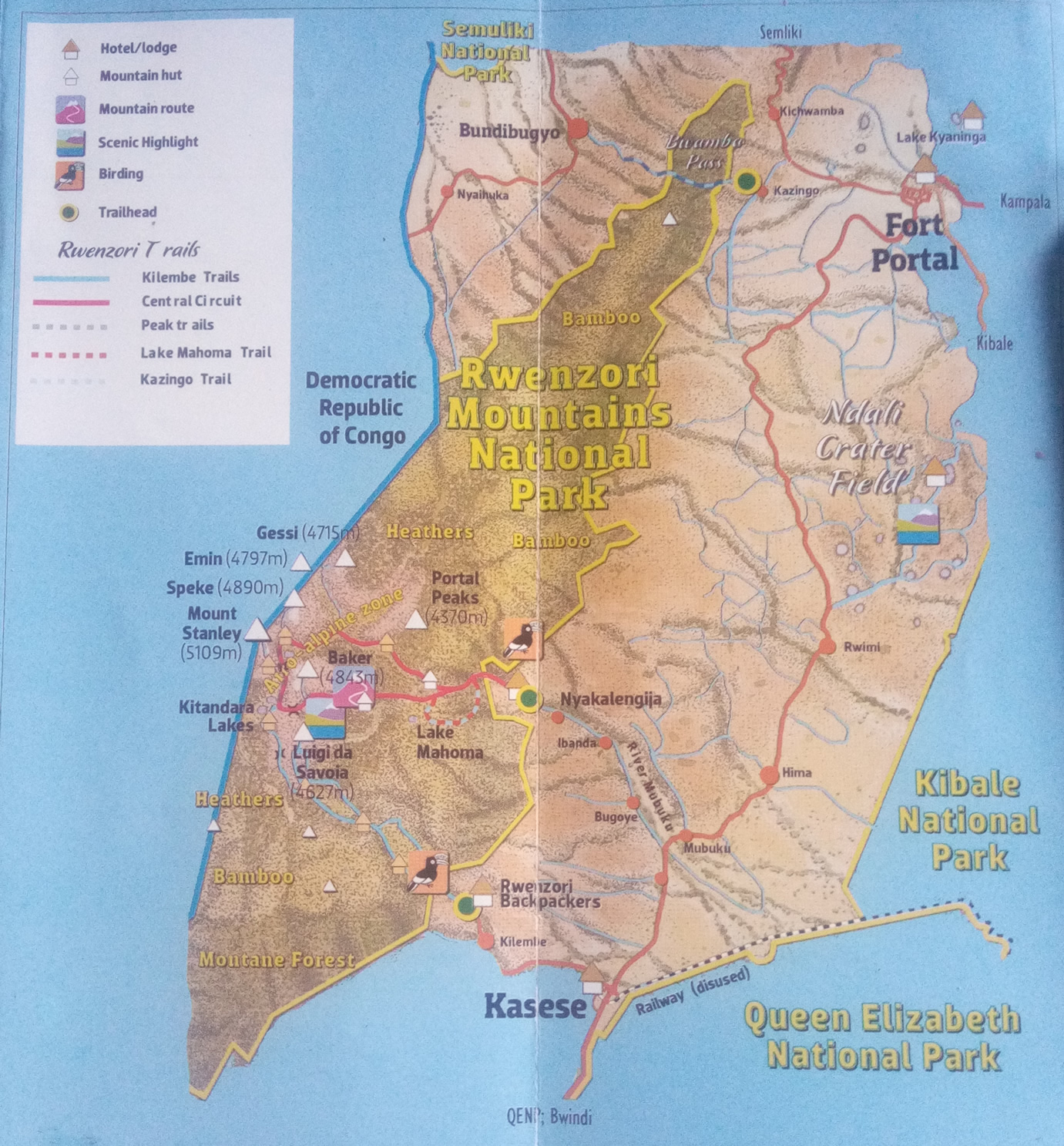
Rwenzori Mountains Game Park covers an area of 995 square kilometers and was gazette in 1991 and after 3 years, it was recognized as a world heritage.
Attractions
A trip into the Rwenzoris is indeed an exhilarating and rewarding experience with its fauna and flora.
Wildlife
The Mountain Rwenzori National Park is home to 18 species of mammals such as elephants, buffaloes and giant forest hogs, 217 species of birds like the Rwenzori turaco and double collared sunbird. The park also has 9 species of reptiles such as the rare three horned chameleon and 6 species of amphibians.
Vegetation
The flora of the park is also an outstanding attraction itself. It is divided into montane forests between the park boundary and the 2500m contour, bamboo between the 2500m – 3000m followed by groves of Rapanea and giant heathers garlanded with lianas, epiphytes and lichens. Between 3000m and 4000 is the garishly colored mosses and beyond 4000m, the mountainside opens out into moorland dotted different kinds of lobelia and groundsel for which this fault-rifted range is famous of.
The People and Culture
Along the slopes of the mountain, lives the Bakonzo people who take this summit as a center of their culture and cosmology. The peaks are the home to their principal god called Kitasambwa whose name many not be spoken on the mountain.
Others
Besides the mentioned attractions, the ranges are scenic with pristine springs, blue cirque lakes, snow clad peaks and strange vegetation which is attraction not only for all kinds of visitors including adventure lovers, scholars & researchers among others.
Activities
The Rwenzori has become established as one of Africa’s great mountaineering adventures, offering the chance to ascend snow peaks and walk on equatorial glaciers.
Mountain Climbing
It is always a mountaineer’s dream to hike any summit up to its highest peak. Though it is purely adventure, Climbing Mountain Rwenzori is tough. Therefore, it must be well planned as the conditions on the mountain at most times become challenging to even an experienced hiker. Conditions are always very cold and the terrain is very steep and boggy.
A week or more is needed to reach and descend from mountain Stanley.
However, it is truly a rewarding and great adventure to climb this highest mountain range of Africa. You will be helped by the local guides who know every trail on the mountain with porters to help you with the luggage.
Hiking
It is also adventurous to hike through the superb mountain scenery enlivened by equatorial snow and outlandish vegetation. Three trails are possible and getting popular; the Kilembe Trail that goes to mt Luigi da Savoia, offering afroalpine vegetation, patches of equatorial snow and weather permitting grandstand views towards mountain Stanley.
Another trailhead is the Nyakalengija that offers a 2-day hike to the scenic Lake Muhoma in the bamboo forest. The Kazingo trail enables a day-long traverse of the North Rwenzori ridge between the Fort Portal plateau and Bundibugyo town in Semliki Valley on the west of the mountain.
Forest Walks and Birding
A nature walk on the Kilembe and Nyakalengija trailheads is truly rewarding for birders. You will look out for the Rwenzori Turaco and Rwenzori double collared sunbird and other localized rarities such as the horned chameleon and Rwenzori colobus.
How to get there
The Rwenzori lies a few kilometers north of the equator, rising over 4000m above the floor of the Albertine Rift Valley. The park trailhead at Nyakalengija can be reached from Kampala from the north via Fort Portal (375km) or the south passing through Mbarara and Queen Elizabeth National Park (450km).
Nyakalengija is 17km off the Kasese-Fort Portal road and 25km north of Kasese town. Charter flights to Kasese can be arranged from Kampala (Kajjansi) or Entebbe International Airport.
Accommodations
There are several accommodation facilities in Mountain Rwenzori national park including Magretta Hotel, Equator snow lodge among others. UWA also provide basic shelters on the Kilembe and Central Circuit routes. Here, climbers have to bring their own sleeping bags and camping mats.
Hikers on Kilembe and Nyakalengija trailheads can also sleep in hotels and lodges from Kasese and Fort Portal as well as tourist lodges in Queen Elizabeth national Park.
Itinerary of the Trail to the highest peak of the mountain
Most of visitors undertake the excellent ‘central circuit’ trial, which takes 9days-8nights to complete and takes you to the main peaks. However, other shorter hikes are possible in the central area and in the North of Rwenzori, taking about 6 nights / 7 days and reaches an altitude of 14,000 ft (4,267 m) above sea level to the equally scenic Mt. Luigi da Savoia.
Meanwhile, high mountain equipment are required, as the trials reach an altitude of 4,000m above sea level.
The periods of July – August and December – February are relatively dry and for inexperienced hikers, and are the best seasons for a trek.
Here is a simple Rwenzori Climbing Itinerary;
Day 1: Transfer to Kasese
Our driver/ guide will pick you either from the Airport – Entebbe, in Kampala or any other location you prefer to start on the 297km journey to Kasese, where the Mountain Rwenzori National Park is found.
Dinner and overnight at Hotel Margherita
Day 2: Beginning of Mt Rwenzori climbing
Arrive at the Rwenzori Mountaineering Services (RMS) offices at Nyakalengija in the morning so as to have ample time to rent equipment and be availed with guides that will take you to the through the journey to the top of the mountain as well as porters to carry your luggage.
Hiking begins from the Park Headquarters that is 54,00ft (1,646 m), walking past typical ‘mud and wattle’ Bakonzo homes and gradually moving upward through elephant grass and garden plots.
The trail then follows the Mubuku River and involves climbing over rocks and bluff, before reaching the Mahoma River in about two and a half hours.
After crossing the river there will be a steep climb through open bracken fern slopes and Podorcarpus Forest up to Nyabitaba hut that is at 8,700 ft (2652 m). This is where you get your first overnight from.
You may be able to hear chimpanzees, and sometimes see black and white colobus monkeys behind the hut, and catch glimpse of brilliantly coloured Rwenzori Turaco.
Across the alley to the north of Nyabitaba hut lies the rocky and largely unclimbed Portal Peaks, which rise above 14,000 ft (4, 627 m).
Note:
- Overnight at Nyabitaba Hut
- Total time for an average hiker from Nykalengija to Nyabitaba is about 5-7 hours, and total elevation gained is 4,000 ft. (1,200 m).
- Slower hikers could take considerably longer, so insist on leaving park headquarters before noon to avoid being on the trials after dark.
Day 3: Hiking from Nyabitaba Hut to John Matte Hut (3414m)
From Nyabitaba Hut, the trail leads westward for a half a kilo meter then drops steeply to Kurt Shaffer Bridge, crossing below the confluence of the Bujuku and the Mubuku rivers.
By turning right the Bridge, you begin to climb the central circuit anti-clockwise since the clockwise direction is much more difficult and adds considerable danger for you and your porters.
After crossing Kurt Shaffer Bridge the muddy, slippery trail climbs steadily up through bamboo forest. After one and a half hours you encounter an area of slippery boulder hopping which some hikers consider the most difficult and dangerous footing of the circuit.
Within five hours from Nyamitaba hut, you will be at the hut at Nyamuleju and its accompanying rock shelter.
On a rare clear day Mts. Stanley and Speke can be seen from the top of the rock near the hut.
- Note that if you had a late start or know that there is a large group ahead of you at the next hut, you can consider spending the night here.
If you choose to continue, Nyamuleju marks the start of the giant lobelia and groundsel zone, this remarkable vegetation type is found nowhere else in the world except high altitude tropical African Mountains.
The one-hour walk to John Matte hut that is at 11, 200 ft (3,414 m) is through a challenging bog, full of extra ordinary plants. A slow pace can be a delightful chance to examine and photograph this unique environment.
Note:
- The typical time to reach John Matte from Nyabitaba hut is about 7 hrs.
- Some hikers consider this to be the most tiring and longest day of the circuit, so an early start is important.
- The loss of altitude to Kurt Shaffer Bridge means the total elevation to be gained on this day is about 3,000 ft (915 m).
- Overnight at John Matte Hut
- If you feel you have reached your limit by this point, you should consider John Matte a reasonable stopping point. You can enjoy the unique vegetation in the bog and the great view, then the following day begin your return journey to Nyabitaba hut.
Day 4: Hiking from John Matte to Bujuku Hut (3962m)
Leave John Matte to cross the Bujuku River and enter the lower Bigo bog, where your first real experience for jumping from tussock to tussock on a grassy bog begins.
The trail is muddy and follows the left (southern) edge of lower Bigo bog until eventually it reaches the round metal ‘uniport’.
In the last half of this bog, a boardwalk has been constructed to make walking easier and prevents the hikers from further damaging the bog. A beautiful narrow stream at the upper end of this bog makes a good lunch break.
An hour and a half beyond this upper bog, and after climbing through drier ground crisscrossing the river, you reach Lake Bujuku. The southern end of the lake is in a majestic setting, with Mt. Baker to the South, Mt. Stanley to the west and Mt. Speke to the north.
Beyond the north end of the lake is a rock shelter called Cooking Pot and a short distance further is Bujuku Hut 13,000ft (3962 m) favorably located for parties climbing Mt. Speke that require technical skills and special equipment.
Note:
- Time to reach Bujuku form John Matte is typically 3 – 5 hours, and the elevation gained is 1,800 ft (560 m).
- The long stretches of bog, and the mud along the lake make this another challenging day.
- The shaded location and frequent mists can make Bujuku Hut quite cold.
- If one moved around on a nature walk, the chances of seeing Red duikers are high and at night, calls of the Rock hyraxes are common.
- Overnight at Bujuku Hut
Day 5: Hiking From Bujuku to Kitandara Hut (4023m)
From Bujuku hut, you will leave directly to the trail which rises and falls twice before finally climbing steeply trough magical moss draped Groundsel vegetation to Scott Elliot Pass.
At the steepest section, is a short strong ladder after which a right hand branch will lead to Elena Hut. When wet or icy, this trip can be slippery.
After a brief rest, start on the second trail to the right to Elena Hut. Elena is the base camp for climbing the 16, 763 ft (5,109 m) Margherita Peak in the Mt. Stanley Complex which requires an additional day or two. This can only be attempted with an ice axe, mountain boots, crampons, ropes and prior arrangements with RMS guides.
Alternatively, you can start on your journey down the mountain. Continue with the circuit trail that continues to the left over Scot Elliot Pass. This enters an alpine zone of spars low vegetation and stark rough boulders more familiar to high altitude climbers from northern latitudes. As you leave the pass, you may enjoy spectacular views northward of Margherita Peak, Elena and Savoia Glaciers, and Mt. Baker that is at 4,843 m, towering above you to the east (left) of the trail.
Having dropped a few hundred feet in elevation from the pass, you cut below massive rock walls at the base of the Mt. Baker.
Here, dramatic ‘impact craters’ have been caused by large rocks falling from above, and your guide may caution you against loud noise! Rising and falling, the trail descends past Upper Lake Kitandara through thick mud to lower lake and Kitandara Hut 13, 200 ft (4,023 m).
This lovely site is surrounded by towering peaks, but the sun sets early and the nights can be cold.
Note:
- Time to reach Kitandara Hut from Bujuku Hut usually takes 3 – 5 hours.
- The elevation gain to the pass from Bujuku Hut is 1,400 ft (425 m),
- Because Scott Elliot is the highest point so far, some hikers will be slower due to greater effort required at these altitudes.
- Watch carefully for signs of altitude sickness.
- Overnight at Kitandara Hut
Day 6: Descending From Kitandara to Guy Yeoman Hut (3261)
An early start is advisable to avoid overheating on the steep but lovely hour-long climb from the Lake Kitandara, which is 14,050 ft (4,282 m) to the Freshfield Pass, a long flat traverse through beautiful alpine mossy glades.
Viewing westward on clear days leads into neighboring Democratic Republic of Congo (DRC) and northward, Margherita and its glaciers still dominate the horizon.
Until after a half-hour, when the trail begins the circuit’s long two-day decent. Mist or rain can make tracking the trail really difficult, and the first one-kilometer here can be very slippery.
Rock Shelter at Bujongolo and Kabamba are optional overnight stopovers but it is better to push on through the seemingly endless mud to newly constructed Guy Yeoman Hut 10,700 ft (3,261 m).
Note:
- Some hikers make the Kitandara Guy Yeoman trip in 5 hours, but any stops to enjoy the pass, bad weather on descent, and the slow conditions in the last two hours of deep mud can make this a much longer day, which some visitors consider as difficult as day two.
- Overnight at Guy Yeoman Hut
Day 7: Descending to Nyamitaba Hut
You are advised to begin the journey early, so as to get to Nyabitaba Hut before dark. In any case the path from the Guy Yeoman is quite difficult in some spots.
Helping each other and descending very slowly facing the slope instead of facing outward is recommended, especially as you approach Kichunchu where the trail parallels twice the crosses Mubuku River mostly in deep mud until the last few kilometers of good dry trail. This follows the ridge down Nyabitaba, which completes the circuit.
Late evening walking can be good for watching birds and you may sight the occasional blue tailed monkey. Sharp eyes can catch a glimpse of the brilliant green but changeable Rhinoceros Chameleon.
Note:
- Typical hikers make the Guy Yeoman to Nyabitaba in 5 hours.
- Should you decide to continue to Nyakalengija, it is another two or three hours depending on the condition of your knees and desire to reach a comfortable bed and bath. Be especially careful about vines and brush and resist the urge to hurry out of the mountains.
Day 8: Transfer to Hotel Margherita
Descend to Park Headquarters to take a comfortable bed and bath and get some rest. It can take 2 – 3 hours from Nyamitaba Hut.
- Dinner and overnight at Hotel Margherita